The NYC DOT and NYPD recently released the Vision Zero Borough Pedestrian Safety Action Plans as part of the Zero Vision Program to reduce deaths and severe personal injury related to traffic accidents in New York City


The Borough Pedestrian Safety Action Plans are one of 63 Vision Zero initiatives designed to eliminate deaths and personal injuries from traffic accidents in New York City. This set of five plans have been developed by the New York Department of Transportation and the NYPD. Each safety action plan addresses specific borough related challenges to pedestrian safety. The action plans are based on the input of the borough inhabitants gathered during multiple community workshops and also from numerous data and comments collected on the interactive Zero Vision map.
Bronx Pedestrian Safety Action Plan
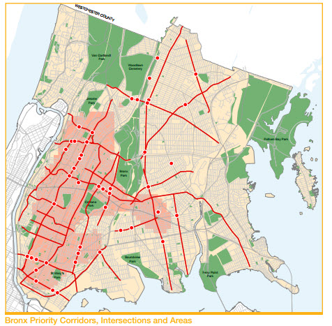 The Bronx pedestrian fatality rate is higher than the NYC average. Most traffic fatalities and personal injuries happen in the high-density neighborhoods in the north- and south-westerly portions of the Bronx. Arterial streets such as The Grand Concourse, 3rd Avenue, and Fordham Road are the most dangerous. A lot of pedestrians are killed when crossing the street mid- block because of the lack of an adequate number of crossroads. The Bronx has a lot of overnight pedestrian fatalities. Seniors represent 36% of the Bronx pedestrian fatalities and young adults 18%. Dangerous driving such as speeding, failing to yield, turning on red distracted driving and DUI are the cause of 85% of the pedestrian fatalities in the Bronx and hit and run occurs in 30 % of cases.
Safety engineering improvements will be implemented at the Priority Corridors, Intersections, and Areas shown on the map on the left. The pedestrian crossing time will be significantly expanded on all Bronx corridors and exclusive pedestrian crossing time will be added to all possible intersections. Signal timing will be modifed to reduce off-peak speeding and 25 MPH speed limit signage will be installed on corridors. A dedicated DOT staff member will reach out to communities with a high number of pedestrian fatalities and severe injuries in the Bronx. Better lighting will be installed under elevated trains and key transit stops. Vision Zero will work with The MTA to develop safer pedestrian environments around Bronx bus lines. Pedestrian crossings will be added and the bicycle network will be expanded. The City will develop pedestrian safety enhancements around new housing development locations that are part of the Housing New York Plan in the Bronx.
Speed cameras will be implemented and additional enforcement will focus on dangerous pedestrian areas and overnight speeding.
Educational campaigns will target children and seniors as well as pedestrians in dangerous areas. Additionally billboard campaigns will target night-time drivers.
The complete Bronx Pedestrian Safety Action Plan can be downloaded here
Brooklyn Pedestrian Safety Action Plan
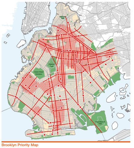 With 2.6 million residents Brooklyn is a large and highly populated borough. Every year an average of 46 pedestrians die in traffic accident in Brooklyn, the highest average of all 5 boroughs however the fatality rate per 100,000 residents is 1.79, the lowest of all boroughs. 60% of pedestrian fatalities occurs on arterial roadways such as Atlantic Avenue, Ocean Avenue, Myrtle Avenue, Rockaway Parkway, 4th Avenue, and 86th Street. Another 36 % of the Brooklyn pedestrian fatalities occur on local streets. Off-peak hours periods are the most deadly with seniors representing 36% of all fatalities. Hit and runs are frequent. Dangerous driving, especially speeding and failing to yield to pedestrians, are the primary cause or a contributing factor in 65% of Brooklyn’s pedestrian fatalities. In most cases the pedestrian was following the law.
Safety engineering improvements will be implemented at at the Priority Corridors, Intersections, and Areas defined in the Brooklyn borough action plan (see map). The pedestrian crossing time will be significantly expanded on all Brooklyn corridors and exclusive pedestrian crossing time will be added to all possible intersections. Signal timing will be modified to reduce off-peak speeding and 25 MPH speed limit signage will be installed on corridors. A dedicated DOT staff member will reach out to Brooklyn communities with a high number of pedestrian fatalities and severe injuries. Better lighting will be installed under elevated trains and key transit stops. Vision Zero will work with The MTA to develop a safer pedestrian environment around Brooklyn bus lines. 60 new speed bumps will be installed in Brooklyn annually. Additional Neighborhood Slow Zones will be developed. Bicycle networks will be expanded. The City will be proactive and will develop pedestrian safety enhancements around new housing development locations that are part of the New York Housing Plan in Brooklyn.
The DOT will deploy speed cameras by schools, in and around Priority Corridors, Intersections, and high-crash locations. NYPD will focus enforcement and deploy additional resources in precincts with high crashe data and also Prioritize targeted enforcement at all 142 mileas of Brooklyn Priority Corridors, 91 Priority Intersections, and 18 square miles of Brooklyn Priority Areas annually.
Multilingual campaigns targeting children and seniors as well as targeted street team outreach will be deployed at Priority Areas, Intersections and Corridors.
The complete Brooklyn Pedestrian Safety Action Plan can be downloaded here
Manhattan Pedestrian Safety Action Plan
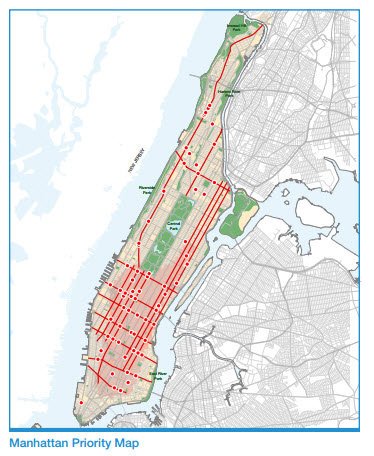 Manhattan is the densest borough with a population that nearly doubles each weekday. Its a borough of pedestrians with one of 5 commuters walking to work and 80% of households not owning a car. The most dangerous areas are the congested corridors such as 42nd Street and busy neighborhoods such as Midtown because that’s also where most commuters are clustered. Pedestrians fatalities represent almost 73% of all traffic fatalities compared to 58% for the entire city of New York. Manhattan has the highest pedestrian fatality rate of all boroughs. Every week on average 6 pedestrians are killed or severely injured in Manhattan; that’s almost one a day. Intersections along arterial roads are particularly dangerous with most fatal accidents happening below 59th street. During rush hours, congestion restrains vehicle speed and the rate of pedestrian fatalities is lower than during off peak times. 27% of all pedestrian fatalities happen at night. This is really concerning considering that less than 3% of pedestrian activity takes place during these hours. Visitors and commuters represent 39% of all pedestrians killed in traffic accidents in Manhattan and seniors 41%. Passenger vehicles and trucks are the cause of pedestrian fatalities with taxis and buses accounting for a small share. Dangerous driving and dangerous pedestrian choices contributed equally to Manhattan’s pedestrian fatalities (43% vs 43%).
Safety engineering improvements will be implemented at the Priority Corridors, Intersections, and Areas defined in the Manhattan borough action plan (see map). The pedestrian crossing time will be significantly expanded on all Manhattan corridors and exclusive pedestrian crossing time will be added to all possible intersections. Signal timing will be modified to reduce off-peak speeding and 25 MPH speed limit signage will be installed on corridors. A dedicated DOT staff member will reach out to Manhattan communities with a high number of pedestrian fatalities and severe injuries. DOT will investigate the feasibility of various policies, such as limiting left-turns from major two-way streets, to improve safety and circulation throughout the Midtown area. The off-hours delivery program will be continued to reduce the number of accidents between trucks and pedestrians. Vision Zero will work with The MTA to develop a safer pedestrian environment around Manhattan bus lines. The bicycle network will be expanded. The City will develop pedestrian safety enhancements around new housing development locations such as the Hudson Yards.
Speed cameras will be implemented near schools and on priority corridors and areas. New resources will be allocated to precincts with a high rate of pedestrian fatalities. Additional enforcement will target 57 miles of Manhattan Priority Corridors, 60 Manhattan Priority Intersections and 6 square miles of Manhattan Priority Areas. The NYPD will also focus on failure-to-yield enforcement during nighttime hours and initiate a series of targeted truck enforcement blitzes to reduce failure to yield and keep large trucks on truck routes. Awareness campaigns will target children and seniors. Target street teams will conduct outreach on safety issues in sensitive areas.
The complete action plan can be downloaded here
Queens Pedestrian Safety Action Plan
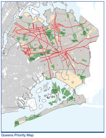 Queens is the largest borough in size and is among the world’s most diverse urban areas with residents representing more than 100 countries and speaking 130 different languages. The urban landscape is as diverse as its population with a mix of densely populated, transit-oriented urban nodes; lower density, suburban-style neighborhoods; and beach communities. JFK and Laguardia airports are also located in Queens. Most crashes and pedestrians fatalities are concentrated in the “downtown areas” of Flushing, Elmhurst and Jamaica as well as along the arterial streets and subway lines. On average one pedestrian is killed or severely injured every weekday. Also in recent years pedestrians fatalities have been increasing in Queens. 56 pedestrians died in 2013 a 51% increase over the previous three-year average. Queens’s pedestrian fatality rate is above the NYC average. Again, most pedestrian fatalities do not happen at rush hour but in 76% of cases during non peak hours with 16% of them happening overnight. 35% of fatalities involved seniors. Dangerous driving contributes to 76% of all fatalities with speeding and failure to yield being the main factors.
As in all other boroughs, safety engineering improvements will be implemented at all areas at at the Priority Corridors, Intersections, and Areas defined in the pedestrian safety action plan (see map). The pedestrian crossing time will be expanded on all Queens Priority Corridors by the end of 2017 and exclusive pedestrian crossing time will be added to all Priority Intersections. Signal timing will be modified to help decrease speeding during off peak hours and additional speed limit signage will be added. A dedicated DOT staff member will reach out to Queens communities with a high number of pedestrian fatalities and severe injuries. Additional lighting under elevated trains and around other key transit stops will be added. Vision Zero will work with The MTA to develop a safer pedestrian environment around Queens bus lines. The bicycle network will be expanded. The City will develop pedestrian safety enhancements around new housing development locations. A recent example is the Hunters Point South development in Long Island City which will be the the largest new affordable housing development to be built in New York City since the 1970’s. This development was coupled with pedestrian and bicycle improvements to the existing streetscape to accommodate the anticipated increase in foot-traffic.
Speed cameras will be installed near schools and priority areas and corridors. Additional resources will be deployed and focus on traffic enforcement in precincts with high rates of crashe fatalities and enforcement will be increased globally along all 127 miles of Queens Priority Corridors, at at all 72 Queens Priority Intersections and within all 17 square miles of Queens Priority Areas.
Multilingual education and awareness campaigns will focus on seniors and children and street-level outreach will be conducted in dangerous areas. In addition, hands-on safety demonstrations such as car safety seat checks, free helmet fittings and giveaways, anti-DWI information sessions, and Saturday table seminars will be made available through Queens council members and community groups.
Download the complete Queens Pedestrian Safety Action Plan here
Staten Island Pedestrian Safety Action Plan
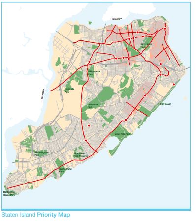
Staten Island is New York City’s most physically distinct borough. 82% of Staten Island residents own a car and two out of three drive to work. Except for the North Shore neighborhoods, the population is not as dense and as pedestrian oriented as any of the other boroughs. North Shore neighborhoods can be characterized as more transit-oriented—with the Staten Island Ferry, Staten Island Railroad, and a dense bus network converging in St. George—and, in turn, the North Shore attracts higher levels of pedestrian activity and therefore the highest rate of pedestrian fatalities of the borough as well. On average, 7 pedestrian die and 40 suffer severe personal injury in a traffic accident on Staten Island every year. This average is the lowest of all NYC’s borough but it has been increasing in recent years. 80% of pedestrian weekday fatalities occur during the afternoon and the evening with almost half of the fatal pedestrian accidents occurring mid-block between two intersections. Staten Island may lack an adequate frequency of safe routes across streets in places where pedestrians want or need to cross.
Safety engineering improvements will be implemented at all areas at at the Priority Corridors, Intersections, and Areas which are mostly located in the North Shore area. Exclusive pedestrian crossing times will be added if feasible on all dangerous intersections and time will be expanded on the existing ones located on all priority corridors. Signal timing will be modified to decrease speeding during off-peak hours. Additional speed limit signage will be installed. A dedicated DOT staff member will reach out to Staten Island communities with a high number of pedestrian fatalities and severe injuries. Vision Zero will coordinate with The MTA to ensure bus operations contribute to a safe pedestrian environment. The City will develop pedestrian safety enhancements around new housing development locations. The bicycle network will be expanded.
Speed cameras will be installed near schools and priority areas and corridors. Enforcement will target Staten Island Priority Corridors, Intersections, and Areas with a Focus on failure-to-yield and speeding enforcement in the afternoon and evening.
Additionally education and awareness campaign will target seniors and children.
The complete Pedestrian Safety Action Plan can be downloaded here